Ming the Mechanic:
The Earth from space

The NewsLog of Flemming Funch
 The Earth from space2005-10-14 15:06
5 comments
picture
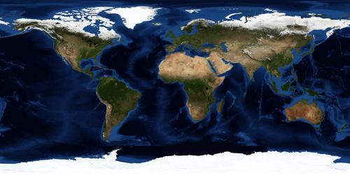
by Flemming Funch

NASA has a new series of "Blue Marble" pictures of the Earth from space, composite pictures, completely without cloud cover. Many resolutions and versions, like here or here, and animations too.


[< Back] [Ming the Mechanic]

Category:  

5 comments

22 Oct 2005 @ 07:43 by taranga @217.158.116.192 : pacific islands from the space station
Following my post on the Gross National Happiness story i did a google image search for the island in the pacific and bingo - not only was i able to get a superb space shot of the tiny spec [20x1 miles] of an island in the Cenral Pacific that i spent a year on, but i could make out the causeways that i was instrumental in helping build 38 years ago!

The image was one of the hand held [to compensate for the fast motion of the space station] digital images taken by the astronauts/cosmonauts out of the window. The detail is astounding resolving [just] objects about 6 foot. If only they had spent a few $ puting an automatic external digital imaging system on the space station, you would be able to read the newspapers on the beach. Come to think of maybe they have but we just don't know about it!  


22 Oct 2005 @ 08:22 by Ge Zi @24.126.199.23 : want to see
taranga - can you show us that island? Give us a link and point out what you build so long ago.  


24 Oct 2005 @ 02:10 by taranga @217.158.116.91 : pacific islands from the space station
I should have thought of that, so here is the link to Tabiteuea South;
http://www.oceandots.com/pacific/gilbert/tabiteuea.htm

The name Tabiteuea translates as "taboo the king" as the island has had no chief or king for serveral hundres years - probably the oldest democracy in the world, The population is about 1700 for the south which is effectively a separate island as it is a 50mile sail to the north, though as you can see they do have an air strip now. The causeways i was involved with are all on the right hand half of the picture but they are more visible if you print out on good quality inkjet paper. For an idea of scale, the largest tidal passage about a third of the way in from the right [also the north] is about 1000 yds.

Once iv'e saved some pennies i'll be getting a decent scanner [epson 4990 preferably] and put my photos on the web.  


24 Oct 2005 @ 04:53 by Ge Zi @24.126.199.23 : fascinating...
... thank you so much - gotta get me one of them islands ;-)  


30 Oct 2005 @ 12:31 by taranga @217.158.116.151 : scale correction Tabiteuea south
my memory was faulty after 38 years - i found my old letters and the largest causeway was 625yds!  


Other stories in
2009-11-01 16:35: Seven questions that keep physicists up at night
2008-10-14 20:33: Where are the podcars?
2008-07-05 00:08: Self-Organized Criticality
2008-05-16 13:34: The Universe as God
2008-01-11 19:00: Richard Dawkins comes to call
2007-12-02 21:10: An E8 theory of everything
2007-09-27 00:46: Parallel universes are a bit more real
2007-07-05 23:40: What happened before the big bang
2007-06-27 00:58: Naïve realism
2007-05-26 02:26: Mars cave


[< Back] [Ming the Mechanic] [PermaLink]? 


Link to this article as: http://ming.tv/flemming2.php/__show_article/_a000010-001585.htm
Main Page: ming.tv