| Photos and street maps | 2005-01-27 23:43 2 comments |
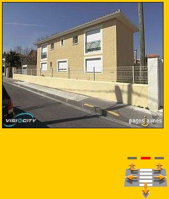
 by Flemming Funch by Flemming FunchI only heard about it yesterday, so I think it is a new thing. The major yellow page site in France, Pages Jaunes, which also serves up maps and other services, now has photos to go with their maps, for most metropolitan areas in France. I.e. a bunch of people have gone around with digital cameras and photographed every street and every house. I thought at first, sure, that would just be the center of town. But, lo and behold, I typed in my own address, and there was a picture of my house. And not just one, but several views. And everything else on our little street. One can click some arrows and take a little virtual walk up and down the street, and turn around and do it again. I couldn't walk on to another street, which was a little annoying. But then I'd probably have been walking around for hours. Oddly, the different pictures from the street were from different times. I can guess why. The first pictures are probably 3 or 4 years old. Our house didn't exist then. So if I "walk" up and down the street, there's an empty lot there, and an old wall. But if I turn to the side and look, there's the house. Still a picture taken before we moved in, as the gate hadn't been painted yet. We moved there 1.5 years ago, when the house was a year old. Anyway, it seems that whoever organized these pictures found out there was a new house built, and sent somebody out to take pictures of it. What an honor. This could all be improved, of course. I don't think there's anything technologically in the way of the pictures being taken in such a way that they could be stitched together into a continuous VR experience. You know, mount a 360 degree camera on top of a car, take a full picture every 5 meters, and GPS code them. And then let me fly through the streets in a fluid motion. And then give me driving directions as a video, rather than this thing with "drive 0.325km to the SE and merge right onto connector road 44b" |